

On the western edge of Nebraska, the prairie rises abruptly into stone. Scotts Bluff National Monument isn’t just a pretty skyline for Gering and Scottsbluff—it’s a waypoint that told generations of travelers they were on the right path. The bluffs stand where the wide, grassy plains tighten into the North Platte River valley. For Indigenous hunters, fur trappers, missionaries, emigrants, and modern-day visitors, this was—and is—a landmark you can trust.
For Indigenous hunters, fur trappers, missionaries, emigrants, and modern-day visitors, these bluffs are more than geology—they’re a stage where human history and natural history converge.
A Landmark Long Before Wagons
People have used this landscape for at least 12,000 years. Paleoindian hunters followed bison and mammoth along the river valleys. Later tribes—the Pawnee, Lakota, Cheyenne, Arapaho, and others—moved seasonally through the valley, leaving stories and trails that predate any pioneer journal.
Euro-American record begins in 1812, when Pacific Fur Company traders documented the bluffs while scouting overland routes. By the 1840s, the scene was changing. Wagon trains streamed west along the Oregon, California, and Mormon Pioneer Trails. The Pony Express thundered through in 1860. The first transcontinental telegraph line, strung in 1861, followed the same corridor. To every traveler, the bluffs meant the same thing: they were on course.
The Name and the Mystery Behind It
The monument bears the name of Hiram Scott, a fur trader who died in 1828 under uncertain circumstances. One version has him abandoned by companions after falling ill, dragging himself more than 60 miles before collapsing near the base of the bluffs. Another claims he was left behind after being injured in a fight. The details vary, but the story captured imaginations. Within a decade emigrants were calling the landmark “Scotts Bluffs,” and the name stuck on maps.
Stone Written by Wind, Ash, and Time
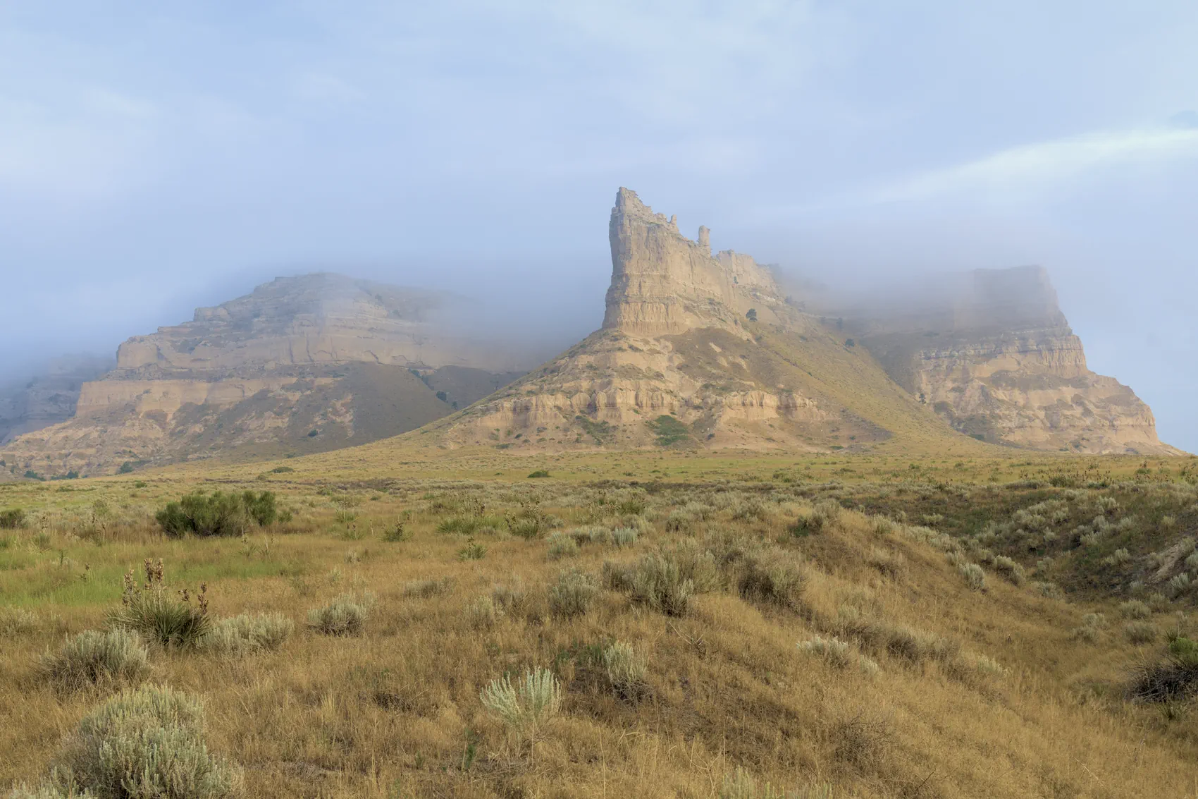
The skyline of Scotts Bluff is a textbook in rock. The exposed formations date from the Oligocene and Miocene epochs—roughly 33 to 22 million years ago. The lowest visible unit is the Brule Formation, a mix of silt, sand, and volcanic ash carried here by ancient rivers and wind. Above it lies the Gering Formation, which records old dune fields hardened into stone. The uppermost Monroe Creek–Harrison formations act as caprock, cemented so tightly they resist erosion while softer layers beneath wear away.
Two volcanic ash beds slice through the sequence, laid down by massive eruptions far to the west about 31 million years ago. Add in the strange “pipy” concretions—vertical tubes of lime cement—and you have a geologic puzzle that still attracts scientists. In short: this is a monument built not by one process but by many. Wind, water, and distant volcanoes each had their hand in sculpting the bluffs.
From Obstacle to Corridor
Early wagon trains detoured south to Robidoux Pass, avoiding the steep badlands near the river. In 1850, laborers cut a shorter route through Mitchell Pass, right between Eagle Rock (part of Scotts Bluff) and Sentinel Rock (South Bluff). This new path shaved nearly 15 miles off the journey and quickly became the main artery for emigrant traffic.
Today, you can still walk the Oregon Trail Pathway through Mitchell Pass. Wagon ruts, troughs, and scars carved into the land more than 170 years ago remain visible. Standing in those ruts, with the bluffs rising above and the North Platte winding below, it’s easy to imagine the creak of wheels, the shouts of ox-drivers, and the weary determination of families who had already traveled a thousand miles with a thousand more ahead.
The Birth of a Monument
By the early 1900s, local residents recognized that Scotts Bluff was not only scenic but historically significant. The Oregon Trail had passed into legend, and the bluffs had become a symbol of western migration. Citizens of Gering lobbied for federal protection, and on December 12, 1919, President Woodrow Wilson proclaimed Scotts Bluff a National Monument.
The designation was just the beginning. In the 1930s, the Civilian Conservation Corps and Works Progress Administration left their mark. Crews carved the 1.6-mile Summit Road, complete with three tunnels, and built a visitor center and ranger facilities. Their work combined Depression-era craftsmanship with engineering foresight, making the bluffs accessible without scarring the skyline. That road, still in use today, is one of the most memorable drives in the National Park System.
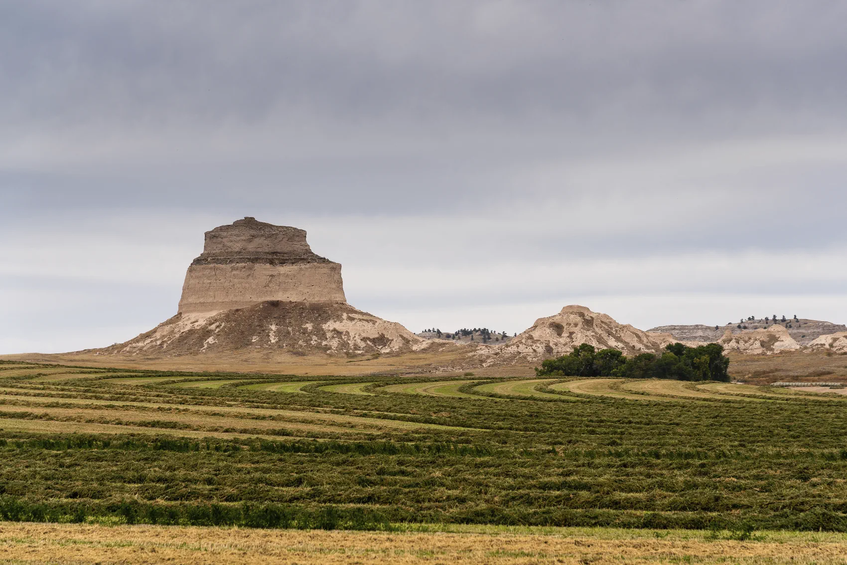
The Five Rocks
Locals know the skyline by its characters: Eagle Rock, Sentinel Rock, Saddle Rock, Dome Rock, and Crown Rock. Each has its own personality. Eagle Rock dominates photographs, a massive prow thrust into the sky. Sentinel Rock stands guard over Mitchell Pass. Saddle Rock offers a hiking trail that winds to the summit, where Crown Rock and Dome Rock frame the horizon. Together, the “Five Rocks” form the jagged façade most people think of when they picture Scotts Bluff.
For the Geology-Minded Traveler
- Eagle Rock offers the clearest look at layers—Brule ash beds in the middle, Gering dunes above, caprock crowning the skyline.
- Why it stands: The caprock is hard enough to slow erosion. Softer layers retreat, leaving cliffs and terraces that catch morning light in stripes.
- Strange features: The “pipy” concretions—vertical stone tubes—give the bluff a ribbed texture near the summit.
Bring binoculars. From the summit, you can see the Wildcat Hills to the south, the Pine Ridge to the north, and on clear days, the faint outline of the Laramie Mountains in Wyoming.
Layers of Human History
The valley below holds its own record. Cottonwoods line the North Platte. Union Pacific rails and Highway 92 follow the emigrant line. In the 19th century, this was an “information corridor” as much as a travel route—the Pony Express and telegraph both squeezed through Mitchell Pass because geography left no choice.
The monument’s visitor center preserves paintings and photographs by William Henry Jackson, who traveled the trail in the 1860s and later documented it for the U.S. Geological Survey. Comparing his images to the landscape outside the window is a reminder of how little the bluff has changed, even as everything else has.
Why It’s Worth the Trip
Travelers today won’t need to ford rivers or face cholera, but the monument is no less compelling.
- History buffs can walk in ruts carved by thousands of wagon wheels, touch the same stone that guided emigrants west, and see artifacts in the visitor center that connect the bluffs to the broader migration story.
- Geology enthusiasts find a rare open book of Oligocene rock layers, volcanic ash deposits, and odd mineral features that reveal the ancient landscapes of the Great Plains.
- Photographers can chase dramatic skies over a cliff line that seems out of place on the prairie. Sunrise paints the rocks in pinks and golds; storm light turns them steel gray.
- Casual travelers find an easy half-day stop with big rewards: a summit drive, short hikes, a comfortable visitor center, and sweeping views of both the plains and the distant Rockies.
It’s also an anchor point for exploring the wider region. The Wildcat Hills State Recreation Area, Chimney Rock National Historic Site, and the rugged Pine Ridge are all within a day’s loop. Scotts Bluff is the gateway not just to Nebraska’s west but to the American West itself.
Practical Visit
- Hike it: Nearly four miles of trails, including the Saddle Rock Trail to the summit and the Oregon Trail Pathway through Mitchell Pass.
- Drive it: Summit Road delivers the best overview, with tunnels adding drama. Parking areas let you get out and explore.
- When to go: Spring and fall offer cooler hiking weather and wildflowers; summer brings thunderstorms that light the skyline; winter dusts the bluffs with snow and solitude.
- Respect it: Stay on trails. The bluff’s surfaces look tough but are fragile. Erosion control is a constant battle.
Why It Matters
Scotts Bluff is proof that the Great Plains aren’t flat—they’re subtle, until they suddenly decide not to be. The bluffs are a natural ramp between grassland and mountains, a stone ledger recording ash falls, dune fields, rivers, and millions of years of change. They’re also a human waypoint: a memory for tribes who named them long before “Scott,” a promise for emigrants chasing a dream, and a Depression-era project that showed how to build access without wrecking beauty.
For modern travelers, that mix is the draw. You don’t just see the view; you stand where millions once paused, take in the same horizon, and feel the same awe. Few places in America pack so much natural drama and cultural meaning into such a small compass. Scotts Bluff is one of them—a place where prairie becomes cliff, history becomes present, and the trail still points west.
- Wikipedia — Nokhu Crags — General facts: elevation, geology, name origin, avalanche risk, and climbing notes.
- Kiddle Encyclopedia — Nokhu Crags — Simplified location, elevation, and geological context.
- SummitPost — Nokhu Crags — Climbing routes, terrain descriptions, and natural history.
- 14ers.com Trip Reports — Firsthand accounts of climbing and skiing routes.
- 14erskiers.com — Nokhu Crags Backcountry Skiing — Details on ski descents, couloirs, and approach routes.
- Front Range Skimo — Nokhu Crags — Couloir names, ski lines, and seasonal notes.
- Newschoolers — Colorado Summer Skiing Guide: Nokhu Crags & Lake Agnes — Ski mountaineering overview and access info.
- USGS Scientific Investigations Report — Geological context, Pierre Shale and intrusive formations in the Never Summer Range.


